Yacht route planning is the strategic process of designing a safe, efficient course from departure to destination by accounting for time-dependent conditions including wind, waves, currents, and your vessel’s own performance characteristics. Sailors and navigators also call this practice passage planning, and the two terms are used interchangeably across cruising and offshore racing circles. Whether you’re crossing the Aegean Sea, threading through the Croatian islands, or heading out into the BVI, a well-built plan is what separates a relaxed, confident voyage from a stressful one. This guide breaks down exactly how it works, what tools you need, and how good planning transforms your time on the water.
What is yacht route planning and why does it matter?
Yacht route planning designs a safe, efficient course by producing optimized, time-dependent waypoints rather than a fixed static line on a chart. That distinction matters more than most beginners realize. A static route assumes conditions stay the same from start to finish. A properly planned passage adapts to forecast changes, tidal windows, and your boat’s polar performance data, so you arrive at the right time, in the right conditions, with a rested crew.
Passage planning is the recognized industry term for this process, and it covers everything from the first chart review at home to the final approach into harbor. Think of it as your voyage’s blueprint. Without it, you’re reacting to the sea. With it, you’re working with it. For families and groups on a sailing holiday, a well-crafted plan also means more time swimming in crystal clear coves and less time beating into an unexpected headwind.
What are the four stages of effective passage planning?
Passage planning follows four stages: appraisal, planning, execution, and monitoring. Each stage builds on the last, and skipping one creates gaps that can turn a minor surprise into a real problem.
1. Appraisal
This is your big-picture research phase. You gather charts, pilot books, almanacs, and tidal data. You identify the nature of the passage: distance, expected duration, crew experience, and any known hazards like shipping lanes, shallow banks, or restricted anchorages.
2. Planning
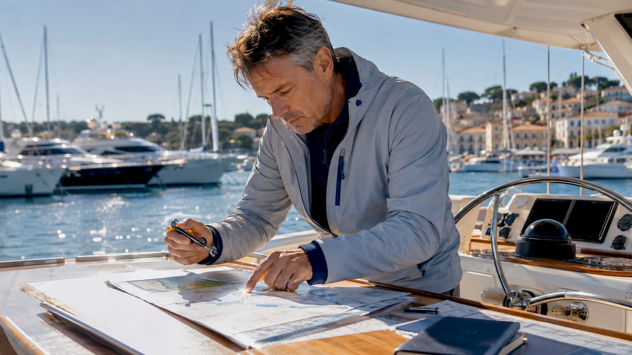
Here you plot your waypoints with bearings and distances, calculate tidal streams, and mark safe-water margins. A documented passage plan includes route waypoints, tidal data, weather forecasts with defined limits, hazard locations, contingency anchorages called bolt holes, and communication schedules. This is also where you brief your crew so everyone knows the plan, their watch responsibilities, and what to do if conditions change.
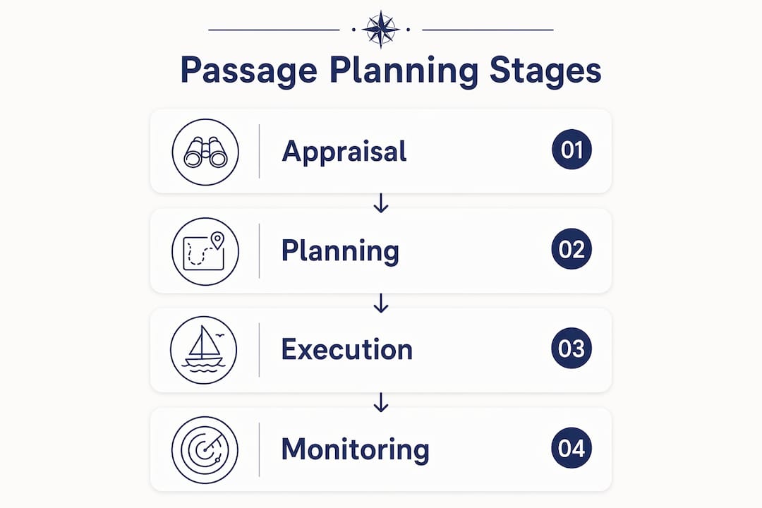
3. Execution
You depart and follow the plan, using your chart plotter, compass, and depth sounder to stay on track. Good execution means staying alert to how actual conditions compare to the forecast, not just following the GPS line.
4. Monitoring
This stage runs continuously from departure to arrival. You compare your actual position and speed against the plan, update your ETA, and watch for any deterioration in weather or sea state.
A complete passage plan also covers these elements:
- Fuel and water reserves relative to passage length
- VHF radio channels and coast guard contacts for each area
- Crew medical considerations and nearest medical facilities
- Entry requirements, customs, and marina booking confirmations
Pro Tip: Brief your crew before departure, not after you’ve left the dock. A 10-minute walkthrough of the plan, the watch schedule, and the emergency procedures gives everyone confidence and keeps the skipper from answering the same questions underway.
How does weather data shape your route decisions?
Weather is the single biggest variable in any passage plan, and treating it as a fixed forecast is one of the most common mistakes recreational sailors make. Historic pilot charts and seasonal patterns are the right starting point for understanding climate and timing before you ever look at a detailed forecast. Resources like NGA pilot charts and Jimmy Cornell’s World Cruising Routes tell you which months favor which passages and what to expect on average.
For the actual passage, you need current weather models. Cross-checking four to five weather models and noting when they diverge helps you decide when to refresh your routing strategy. When models agree, you can commit with confidence. When they diverge sharply, you hold off on locking in a departure time or adjust your plan to build in more flexibility.
Here’s what experienced navigators track when assessing weather for a passage:
- Synoptic charts: Big-picture pressure systems and frontal movements
- Ensemble forecasts: Multiple model runs that show the range of possible outcomes
- Spaghetti charts: Visual spread of track possibilities for low-pressure systems
- Windy app: Accessible, visual wind and wave modeling for recreational sailors
- Sea state and swell period: Separate from wind speed, swell direction and period determine comfort and safety
The difference between weather routing and a static forecast is that weather routing outputs dynamic routes aligned with forecast changes and your boat’s performance polars. This means your waypoints shift as the forecast evolves, keeping you in favorable wind angles and away from building seas.
Pro Tip: Comparing multiple weather models and using their agreement timeline reduces the risk of committing too early to an uncertain forecast. If three models agree on a weather window but one is an outlier, that outlier is worth watching, not ignoring.
What navigation tools and tips help you execute a route plan safely?
The best yacht route planning tools available to recreational sailors today combine electronic chart plotters with dedicated routing software and reliable weather feeds. Popular options include Navionics for chart plotting, PredictWind for weather routing, and Garmin’s chartplotter range for integrated navigation. Each serves a different part of the planning and execution process.
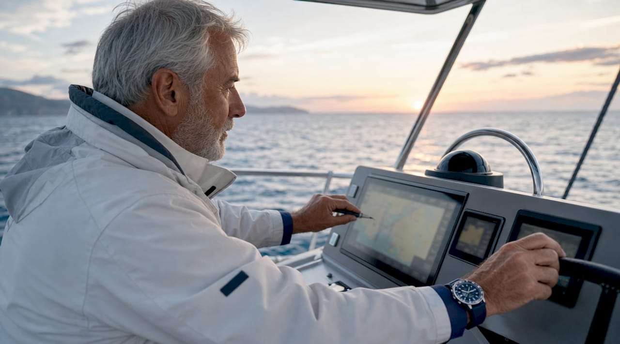
That said, software cannot replace fundamental navigation skills. You need to be able to operate without GPS, read a paper chart, take a bearing, and identify landmarks. Electronics fail. Batteries die. A sailor who can only navigate by screen is a sailor who is one power outage away from being lost.
Proper pilotage practice means marking not only your planned waypoints on the chart but also additional contour lines, hazards, and reference marks. This extra detail becomes critical when you deviate from the route, because you need to know what’s around you, not just where you intended to go. In congested or narrow waters, parallel indexing is a technique that monitors your track relative to the planned course, confirming you remain in safe water rather than relying solely on GPS fixes.
Here are the core yacht navigation tips for executing a plan with confidence:
- Use your chart plotter for situational awareness, not as a substitute for looking out of the cockpit
- Set anchor alarms and waypoint alarms so the boat alerts you before you reach a decision point
- Keep a written log of position, course, speed, and weather observations every hour
- Assign clear watch duties so the skipper is not the only person monitoring conditions
- Routing advice should not be blindly followed. Good seamanship and crew preparedness remain the foundation regardless of what the software recommends.
Pro Tip: Before departure, understand the strategic logic behind your recommended route. If you know why a waypoint is placed where it is, you can adapt mid-voyage without waiting for new routing data to arrive.
How does route planning improve sailing in popular cruising destinations?
Planning a yacht cruising route in the Mediterranean, the BVI, or Thailand is a different challenge than open-ocean passage making. These waters are full of gorgeous anchorages, but also ferry traffic, shifting afternoon winds, and crowded marinas that fill up fast in peak season. Good planning is what lets you enjoy the freedom of the sea without the stress of arriving unprepared.
In Greece, for example, the Meltemi wind blows hard and predictably from the north through July and August. A well-planned route works with that wind rather than against it, routing you downwind through the Cyclades in the afternoon and tucking into sheltered bays before the gusts peak. In Croatia, tidal ranges are small but the Bora wind can arrive with little warning, making bolt holes and contingency anchorages a non-negotiable part of any plan. The role of itinerary in charter success comes down to exactly this kind of local knowledge baked into the plan.
Here’s a quick comparison of planning priorities across popular sailing regions:
| Destination | Key weather factor | Planning priority |
|---|---|---|
| Greece (Cyclades) | Meltemi (N wind, July to August) | Route downwind, depart early morning |
| Croatia | Bora (NE squall, year-round) | Identify bolt holes, monitor forecasts closely |
| BVI | Trade winds (E, consistent) | Straightforward routing, focus on anchorage timing |
| Sardinia | Mistral (NW, strong and sudden) | Flexible itinerary, avoid exposed anchorages |
| Thailand | Monsoon seasons | Plan around SW (May to Oct) and NE (Nov to Apr) windows |
For group and family charters, personalizing your yacht holiday starts with the route. A plan that builds in a mix of sailing days and relaxed anchor days keeps everyone happy, from the keen sailors who want to cover distance to the guests who just want to float in a secluded bay with a cold drink. Safety, comfort, and fun are not competing priorities. A good plan delivers all three.
Key takeaways
Yacht route planning is the structured process of designing a passage around dynamic conditions, and it requires four stages, reliable weather data, the right tools, and the seamanship to adapt when reality differs from the forecast.
| Point | Details |
|---|---|
| Four-stage structure | Appraisal, planning, execution, and monitoring form the backbone of every safe passage plan. |
| Weather drives decisions | Cross-check multiple models and use ensemble forecasts to time departures and update routes. |
| Tools support, not replace, skills | Chart plotters and routing apps are aids; paper chart skills and situational awareness remain non-negotiable. |
| Destination knowledge matters | Local wind patterns like the Meltemi or Bora shape route choices as much as any software recommendation. |
| Planning enhances the experience | A well-built plan means more time enjoying secluded anchorages and less time managing avoidable problems. |
Why I think most sailors underestimate the planning stage
Most sailors I’ve seen get into trouble on the water did not lack skill. They lacked preparation. They checked one weather app, drew a line on the chart plotter, and called it a plan. The sea rewarded that approach with a beat into 25 knots of wind they could have avoided by leaving six hours earlier or choosing a different route entirely.
The part of passage planning that gets skipped most often is the appraisal stage. People want to get to the planning part, the waypoints and the charts, without first asking the big questions. What is the nature of this passage? What are the worst conditions we might face? What does the crew actually need to be comfortable? Answering those questions honestly changes the plan every time.
Modern routing tools like PredictWind and Windy are genuinely excellent, but they work best when you understand why they’re suggesting what they’re suggesting. A routing algorithm does not know that your crew gets seasick in a beam swell, or that you want to stop at a particular island for lunch. That judgment is yours. The technology is there to inform it, not replace it. The sailors who get the most out of their voyages are the ones who treat the plan as a living document, not a locked-in itinerary. They check the weather every morning, they talk to local skippers, and they change course when the conditions call for it. That flexibility is not a failure of planning. It is the point of planning.
— Sail
Plan your next voyage with Sailarmada
Knowing how to plan yacht routes is one thing. Having an experienced skipper and a curated itinerary built around your group’s preferences is something else entirely. Sailarmada offers private sailing holidays across Greece, Croatia, Italy, Sardinia, Turkey, and beyond, with routes designed by skippers who know these waters intimately. Whether you’re booking for a family, a group of friends, or a special occasion, every charter comes with a thoughtfully planned route that balances sailing adventure with breathtaking stops. Explore your options and see how a private yacht charter can turn a great trip into an unforgettable one.
FAQ
What is the difference between passage planning and weather routing?
Passage planning is the full berth-to-berth process covering charts, hazards, tides, and contingencies. Weather routing is a specific component that optimizes waypoints based on forecast conditions and boat performance.
How many weather models should I check before a passage?
Checking four to five weather models and comparing their agreement gives you a reliable picture of forecast certainty. When models diverge, delay your departure decision until they converge or build more flexibility into your plan.
What tools do recreational sailors use for yacht route planning?
Popular tools include Navionics for chart plotting, PredictWind for weather routing, Windy for visual wind and wave modeling, and Garmin chartplotters for integrated onboard navigation.
Can I rely entirely on GPS and routing software for navigation?
No. Software and GPS are powerful aids, but fundamental skills like reading paper charts, taking bearings, and identifying landmarks are non-negotiable backups when electronics fail.
How does route planning differ for Mediterranean sailing?
Mediterranean route planning requires understanding regional wind systems like the Meltemi in Greece and the Bora in Croatia, identifying bolt holes for sudden weather changes, and timing departures around predictable afternoon wind patterns.